A miniaturized GPS system and WinTrack software for analysis of homing paths in pigeons
H.P. Lipp1, C. Bürgi2,3, S. Werffeli2,3, I. Steiner1, G. Tröster2 and D.P. Wolfer1
1Institute
of Anatomy, University of Zürich, Zürich, Switzerland
2Institute for Electronics, Swiss Federal Institute of Technology,
Zürich, Switzerland
3µ-blox AG, Zürich, Switzerland
How pigeons find their way back home is still enigmatic, although partial mechanisms have been identified. The importance and interaction of putative mechanisms such as perception of magnetic fields and olfactory processes remains a matter of debate, however. The experimental analysis has been impeded by the crude behavioral techniques to analyze the orientation of the birds, namely vanishing bearings at the release site and recording of homing times. Hence, future analysis requires routine recording of the homing path.
Several path recording methods have been tried: tracking by airplanes and helicopters (costly and difficult), triangulation of pigeons carrying radio emitters (tedious and limited), tracking pigeons carrying radio emitters by the ARGOS satellite system (localization error up to 3 km), and compass-based route recorders [1] which have been successfully employed for more than 10 years, with one important limitation: calculation of flight paths from angular changes during flight requires the assumption of constant flight speed. This restriction, however, is not present in data loggers using global satellite positioning (GPS) as they record both true geographic location and flight speed.
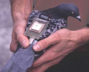
Here we present a miniaturized GPS tracking system with an overall weight of 33 g (including casing and battery), carried on the pigeon's back. It is based on the GPS chip of the company µ-blox. The chip is controlled by a microprocessor permitting data logging for three hours in continuous mode, and up to 8 hours in energy-saving mode. After return of the pigeon, data are downloaded and analyzed using the homing pigeon module of WinTrack (D.P. Wolfer). This program eliminates recording artifacts, reconstructs missing data points, calculates common variables such as path length, speed, average distance to target, but also more complex measures such as directionality of circling at the start, path tortuosity and quantitatve similarities between different flight paths. A macro language permits to define and extract new variables from the stored data if necessary. In collaboration with the GFT Gesellschaft für Telemetrie-Systeme mbH (R. Laschefski-Sievers, Horts, Germany), the system is being expanded to communicate with the ARGOS satellite system.
Figure 1. GPS route recorder on the back of a homing pigeon. Casing has been removed for better view.
At present, we are testing a set of prototypes and expect that this GPS system will permit to re-analyze a number of classical problems in homing pigeon research. In addition, we expect that these route recorders will permit studies that require constant path tracking, such as the problem whether pigeons read continuously geomagnetic or other cues during homing, or whether they rely on a navigational strategy known as dead reckoning.
Supported by SNF 3152-058822.
Poster presented at Measuring Behavior 2000, 3rd International Conference on Methods and Techniques in Behavioral Research, 15-18 August 2000, Nijmegen, The Netherlands